Sitio web de Remigio Pérez Physical Education in Bilingual Proyects
ORIENTEERING WITH NEW TECNOLOGY (ORIENTEERING APP)
ORIENTEERING
Orienteering is a sport that requires navigational skills using a map and compass to navigate from one point to another in unfamiliar terrain. Participants are given a map, usually a specially prepared orienteering map, which they use to find control points. It was originally a training exercise for military officers, but it has now become a federated sport. The International Orienteering federation recognises four types of orienteering: → Foot orienteering → Mountain bike orienteering → Ski orienteering → Trail orienteering ( in wheelchair) But many times, orienteering is included in adventure raids or mixed with other sports, as horse riding or canoeing.
The Map: Orienteering maps are very detailed topographical maps (they show hills and valleys). Their scales are 1:15,000 or 1:10,000, wich means every cm in the map equals 15.000 or 10.000 cms (150 or 100m) on the terrain. Map symbols are standardized by the IOF, and designed to be readable by any competitor. The orienteering course is marked in purple or red on a map. A triangle is used to indicate the start and a double circle indicates the finish. Circles are used to show the control points. Every other part on the map (rivers, roads, etc) has a specific colour.
Map colours: Black symbols are used for rock features (for example, boulders, cliffs, stony ground) and for linear features such as roads, trails and fences as well as for other man-made features (for example, ruins and buildings) Brown symbols are used for landforms such as contour lines, small knolls, ditches, earthbanks. Blue is used for water features: lakes, ponds, rivers, streams, marshes. Yellow is to show vegetation - specifically for open or unforested land. The density of the yellow color shows how clear the area is: brightest yellow for lawns, pale yellow for meadows with high grass. Green is used to show vegetation that slows down the passage of an orienteer. The darkest green areas, called "fight", are almost impassably overgrown. White on an orienteering map signfies forest with little or no undergrowth - forest that an orienteer can run through. Purple (or red) is used to mark the orienteering course on a map. Conditions that are specific to an event (such as out-of-bounds fields in which crops are growing) are also designated in red or purple.
Controls: Control points are marked in the terrain by white and orange "flags". Control card and punching: Each competitor must carry a control card, and has to present it at the Start and hand it in at the Finish. The control card is marked at each control point to show that the competitor has completed the course correctly. (Usually with needle punches, but most events now use electronic punching). A needle punch: Results: The winner is the competitor who has found and passed through all control points with the fastest time. You can see an orienteering race using electronic punching in this video: There are maps on the bottom sides to show you how the racer is progressing from one control point to the next one.
Orienteering Special Terms:
Control: This is the point, circled on the map, which you are looking for. The (usually) orange and white marker there is called a control marker. Course: The orienteering course is the set of controls you are looking for. Leg: A leg is the portion of a course between two consecutive controls. Knoll: A small hill. Contour: A brown line used to show topographic features. A contour is a line tracing land of a given elevation. Using contours, the shape of most landforms -- hills, valleys, slopes, knobs, even kettleholes and sand dunes -- can be shown. Linear feature: A trail, stream, fence, stone wall, or other feaure that is basically linear. Contrast this with point features, like boulders, wells and springs, and area features, like fields and lakes. Catching features: A large feature which is not easy to miss in the direction you are going. You might use a catching feature, such as a lake beyond a control, to "catch" you if you miss the control.
HIKING
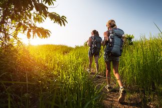
Hiking is a long, vigorous walk, usually on trails or footpaths in the countryside. "Hiking" is the preferred term in Canada and the United States; the term "walking" is used in these regions for shorter, particularly urban walks. In the United Kingdom and the Republic of Ireland, the word "walking" describes all forms of walking, whether it is a walk in the park or backpacking in the Alps. The word hiking is also often used in the UK, along with rambling (a slightly old-fashioned term), hillwalking, and fell walking (a term mostly used for hillwalking in northern England). The term bushwalking is endemic to Australia, having been adopted by the Sydney Bush Walkers club in 1927.
In New Zealand a long, vigorous walk or hike is called tramping. It is a popular activity with numerous hiking organizations worldwide, and studies suggest that all forms of walking have health benefits.
In the United States, Canada, the Republic of Ireland, and the United Kingdom, hiking means walking outdoors on a trail, or off trail, for recreational purposes. A day hike refers to a hike that can be completed in a single day. However, in the United Kingdom, the word walking is also used, as well as rambling, while walking in mountainous areas is called hillwalking. In Northern England, Including the Lake District and Yorkshire Dales, fellwalking describes hill or mountain walks, as fell is the common word for both features there. Hiking sometimes involves bushwhacking and is sometimes referred to as such. This specifically refers to difficult walking through dense forest, undergrowth, or bushes where forward progress requires pushing vegetation aside. In extreme cases of bushwhacking, where the vegetation is so dense that human passage is impeded, a machete is used to clear a pathway. The Australian term bushwalking refers to both on and off-trail hiking.
Common terms for hiking used by New Zealanders are tramping (particularly for overnight and longer trips), walking or bushwalking. Trekking is the preferred word used to describe multi-day hiking in the mountainous regions of India, Pakistan, Nepal, North America, South America, Iran, and the highlands of East Africa. Hiking a long-distance trail from end-to-end is also referred to as trekking and as thru-hiking in some places. In North America, multi-day hikes, usually with camping, are referred to as backpacking.
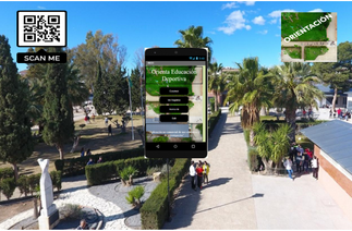
New Tecnology and Orienteering (Our class in PE)
-Orienteering App
-QR CODES
-Map/Compass/Time
-Questions/Videos/Pictures
-Groups of 3-4 students
Comentarios recientes
05.10 | 09:57
Buenas tardes, encantado de saludarte. Soy Jose
Quería escribirte porque me ha parecido interesante comentar contigo la posibilidad de que tu negocio aparezca cada mes en periódicos digitales como not
08.09 | 09:54
Hola. ¿Cómo estás? Soy Alberto del Departamento de Prensa. Muchas gracias por atenderme.
He pensado que podría interesarte cómo podemos hacer que tu empresa aparezca en más de 50 periódicos digitales
23.07 | 05:21
Hola. ¿Cómo estás? Soy Alberto del Departamento de Prensa. Muchas gracias por atenderme.
He pensado que podría interesarte cómo podemos hacer que tu empresa aparezca en más de 50 periódicos digitales
24.04 | 16:48
Buenas tardes Alberto, te puedes poner en contacto conmigo mediante el correo electrónico, no veo ningún problema en que aparezca en prensa digital. Un saludo
Compartir esta página


